East Anglia One Windfarm - Questions and Answers
This information has been collated and written by Phil Holmes based on information provided by Scottish Power direct to him, and from further information on their website.
1. What is East Anglia One?
It is an offshore windfarm to be built in the North Sea 42 km (26 miles) off the Suffolk coast. It will generate 714 megawatts (MW) peak - somewhat over half the power Sizewell B currently generates. It is planned to be operational by 2020.
2. How will it connect to the National Grid?
Underground cables will come ashore at Bawdsey and will cover 37 km (23 miles) to reach a National Grid substation at Bramford. The cables will carry power at 220,000 volts (220 kV). For comparison, the overhead power lines that start at Sizewell and go to the North of Grundisburgh operate at 400 kV - nearly twice the voltage.
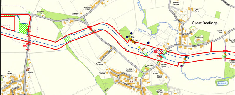
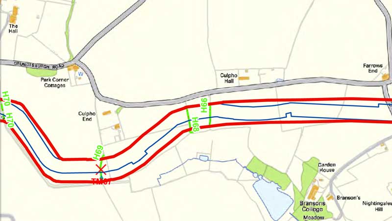
3. What's the route through Bealings and Playford?
Please see the maps (not to the same scale) below. (These 2 maps miss part of the route between Church Road and Butts Road, Playford. Apologies - this is not shown on the series of maps that I think best shows the route. In practice, it's a pretty straight line, dominated by the compound being built there.)
4. What work will be taking place?
There are three phases of construction: Pre-construction activities; construction and reinstatement. Further detail below:
Pre-construction
- Ecological Mitigation inclusive of works at the River Lark for Vole Displacement - to be undertaken in early March 2017.
- Archaeology in fields either side of the Bealings
- Road Improvements - Installation of Passing Places along Lodge Road and Seckford Hall Road
- Tree and Hedge Removal – due to start in March. Further information is here.
Construction
- Installation of Access Points (points on roads used to get to and from the cable route)
- Installation of Construction Consolidation Sites (CCS) Sites. These are compounds which will be utilised to provide welfare, site staff accommodation, parking, and secure storage for materials, plant and equipment
- Installation of Boundary Fencing
- Topsoil removal and installation of Haul Road (the temporary road running along the cable route)
- Installation of Ducting (pipework) – open cut using trenches. This includes the River Lark, and Holly Lane (short term, 5-days max road closure required for Holly Lane) – note that on completion of all works Holly Lane will have to be reinstated in full, full width for approx. 15m so a further short term, up to 5 days closure, will be required.
- Auger (drill) Bore – Lodge Road (Lodge Road is still a crossing point to allow access from one side to the other.
- Cable Installation and Cable Jointing – joint bay identified in field off Lodge Road.
Reinstatement
This is still in review, but current plans are:
- Take out haul road and reinstall top soil.
- Tree and Hedge Planting - hedgerows and trees will be reinstated two in place of one.
- Remove fencing
- Remove CCS Sites and Access Points
- Remove Road Improvements – where not required to stay in situ (to be agreed with SCC).
- Continued monitoring and management of replanting.
5. What are the timescales for the work?
It's not possible to say at this point. Archaeological work might reveal finds that delay work in particular areas.
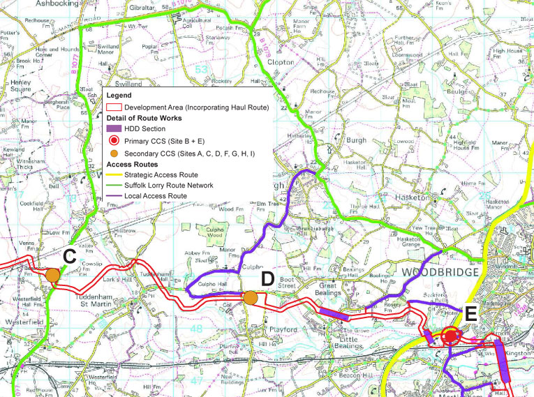
6. What extra traffic will there be near Bealings and Playford?
All construction HGV movements will be along the already approved construction access routes. These are shown in the image below.
There are maximum daily HGV movements for each access road that must not be exceeded. These are shown below and are directly taken from the approved report. For example, it shows that Ipswich Road through Grundisburgh down to Construction Consolidation Site D near Playford will have a maximum of 58 HGV movements along it per day, a 44% increase.
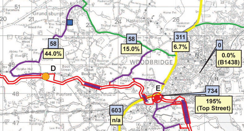
In addition, there are also Peak Hour restrictions (morning and evening) on both total construction vehicle movements and HGV movements. Peak hours are defined as 8-9am and 5-6pm. Along Ipswich Road through Grundisburgh down to CCS D there will be a maximum of 4 construction vehicle movements between 8-9am and 7 construction vehicle movements between 5-6pm.
7. What is actually being buried?
For EA ONE six ducts (pipelines) will be installed in a triangular/trefoil configuration in two trenches. There will also be two smaller ducts to carry fibre optic cables. Inside the ducts will be the high voltage cables. At the same time a single trench will be dug (with associated ducting) for EA THREE as advanced preparatory work. At present, there are 2 options under consideration for the layout of the trenches - option 1 has the temporary access road between the trenches for EA1 and EA3. Option 2 has the 3 trenches together and the access road to one side. Option 2 is illustrated below - please click on the image for a larger version.
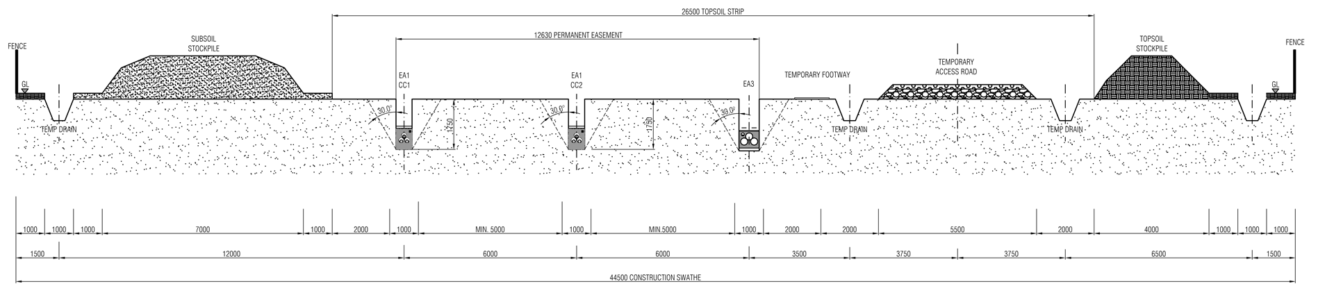
As shown, the total width of the construction swathe from fence to fence is 44.5 metres. The trenches are typically 5 metres apart and 1.75 metres deep.
8. How are road and river crossings managed?
Road and river crossings will be performed by a variety of methods, depending on where they are and the make-up of the soil.The River Deben, Kirton Creek, Martlesham Creek, the A12 and A14 and Miller's Wood at Bramford will be crossed using Horizontal Directional Drilling (HDD).
In areas where it is not possible to undertake an HDD, but where it's still necessary to drill, another drilling method such as auger boring will be used.
However, much of the cable route will be trenched - or open cut - including the River Lark near Lodge Road and Holly Lane, as mentioned above.
9. What are future plans for the use of the cableway?
As mentioned above, the cable route will also be used for the East Anglia THREE project. High voltage DC cable will be installed in the duct from Bawdsey to connect at a substation at Bramford.
10. What is the difference between AC and DC?
AC is alternating current - the same as is used in households and overhead transmission lines. The direction of the current reverses 100 times a second, and is always changing. DC is Direct Current - the current always flows in the same direction.
There are considerable differences that affect the cost and efficiency of each. However, for those near the route, the only major difference is in the emissions from the cables. Both types of transmission cause electric fields and in overhead transmission these can be significant. In underground cables like these, the ground shields the electric field and so there is no effect at or above ground level.
The changing current of AC transmission means that it also creates magnetic fields (EMF) which are not fully shielded by the soil. There are no magnetic fields with DC transmission.
11. Is this safe?
[This section was contributed by John Wittgreffe, a resident of Little Bealings]
I have been in discussion with Scottish Power on this issue and I am also part of a monitoring team, living in Little Bealings. The answer is that there should be no concern, as the techniques employed in this development result in very low electromagnetic fields (EMFs). For those interested in more information on how we have reached this conclusion, please read on.
All powerlines and power sources emit both electric and electromagnetic fields arising from the electrical currents they carry. Whilst electric fields can be shielded, electromagnetic fields permeate easily through walls and soil and so they are sometimes the subject of public controversy especially in regard to high voltage powerlines. However Scottish Power will employ modern buried cabling techniques, where not only are the electric fields shielded, the EMFs are also cancelled out by using closely adjacent wires with opposing currents.
There is a recognised threshold for an acceptable level of EMF from the International Commission on Non-Ionizing Radiation Protection (ICNIRP) which is used by planners. This is 100 micro Teslas (µT). This is the level below which effects can no longer be detected in the human body and is based on short term exposure.
There is also a figure for long term exposure (years) from the World Health Organisation, based on studies from the International Agency for Research on Cancer (IARC) and other sources internationally, which is 0.4µT. It is assigned Class 2B which in essence means that statistically an adverse effect can’t be fully ruled out in a small % of people above this number, yet this can’t be fully proven either as the mechanisms are not yet understood. The WHO state that there is no reliable data showing any negative effects below 0.4µT.
Scottish Power have now provided us with a distance profile of the low frequency electromagnetic field (EMF) strength for the development. This shows that when standing directly over a trench, the EMF is 7µT at 1m above ground, dropping off to around 0.2µT at 30m away and negligible from 40m.
So it is clear that the EMF from our powerline is over 10 times less than the ICNIRP even when standing directly above a trench and is less than even the more sensitive IARC figure at 30m. Due to the boundary there is therefore no cause for concern.
We live in EMFs all the time from our home wiring and electrical appliances. The average EMF in a typical home is 0.07 µT and can be much higher a few cm from running appliances such as shavers or vacuums (e.g. above 2µT). A personal viewpoint is that I would only be concerned if EMFs in my home were substantially above the IARC number continually.
After looking into this in detail, I am reassured by the data for our powerline. If you would like any further information on the above, please do contact.
John Wittgreffe, BSc Hons Physics, contact john.wittgreffe@btinternet.com .
Copyright ©Phil Holmes 2017